Sentinel Birds of Coastal Risks
SENTI•RISK: Sentinel birds monitoring our changing coasts
The SENTI-RISK project (Sentinel Birds of Coastal Risks) is a research program studying movement ecology to assess the vulnerability of the Bay of Biscay’s coastal interfaces in the face of global change. By relying on high-resolution GPS telemetry, the project aims to identify areas under anthropogenic pressure and analyze the behavioral plasticity of individuals in the face of a changing environment.
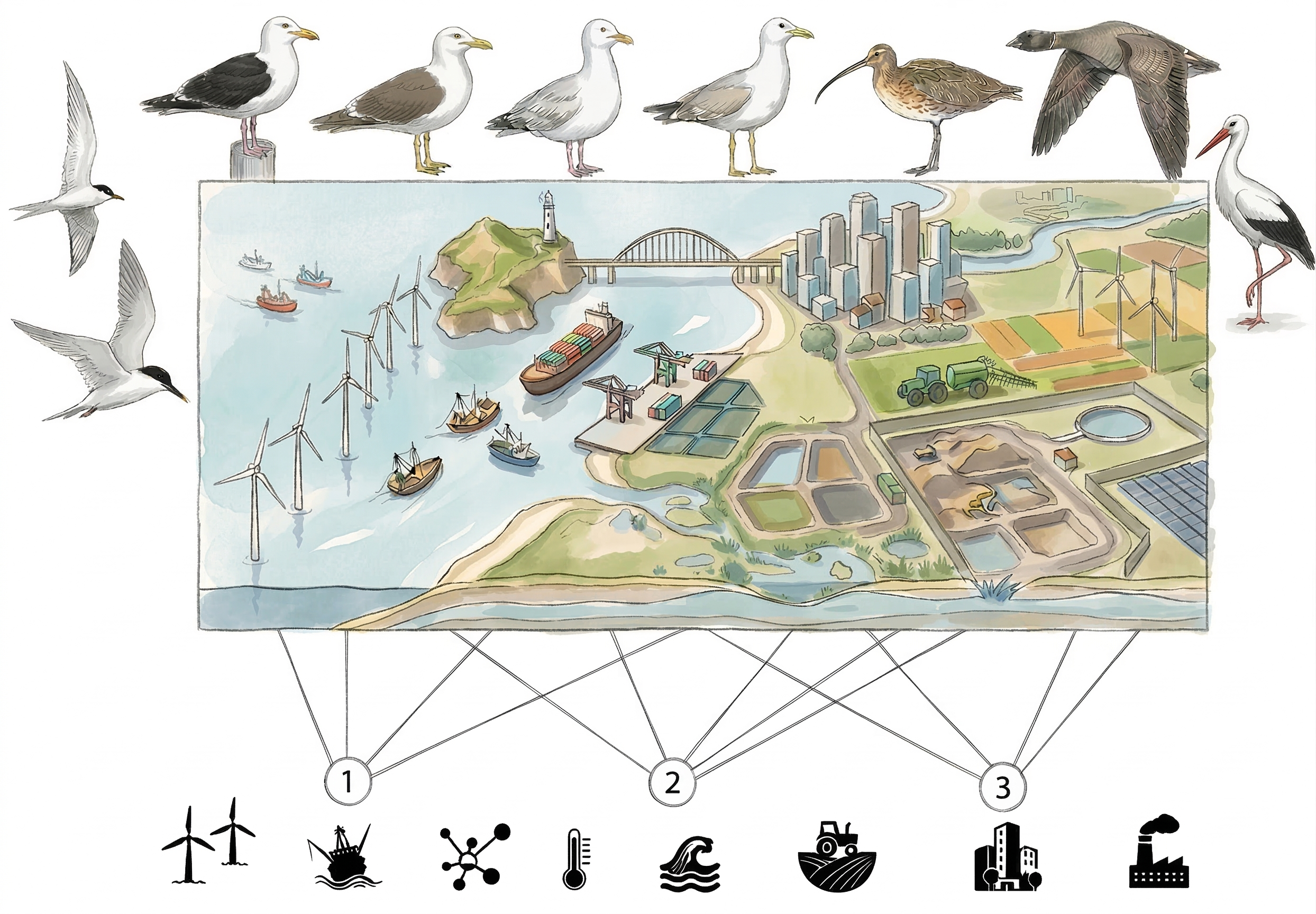
Legend: Sentinel birds facing the gradient of coastal risks (Click to expand!)
Based on the representative example of the Pertuis Charentais, this diagram illustrates the connectivity between coastal ecosystems and the pressures studied by the project across the Bay of Biscay.
1 Offshore pressures and risks: This zone concerns the intensification of offshore activities, notably the development of offshore wind farms and increased maritime traffic. Seabirds (terns, gulls) can serve as indicators of the impacts of these new infrastructures.
2 Interface dynamics and global changes: At the interface, this zone combines physical constraints related to climate (temperatures, wind patterns) and coastal risks (submersion, mudflat erosion).The sentinels of this zone (gulls, curlews, geese) reveal the adjustment capacity of populations in response to the modification of their feeding grounds
3 Terrestrial and continental anthropogenic pressures: This zone, corresponding to the watershed, is directly affected by the impacts of urbanization, intensive agriculture, and industrial areas. Species nesting or foraging inland (gulls, storks) make it possible to quantify the shifting of pressures from the coast toward the mainland.
The role of sentinel species: At the top of the figure, the GPS-tracked species can act as indicators of the significance of these three major land-sea pressure classes.
The coastline: a critical interface under cumulative pressures
Coastal areas, as true interfaces between marine and terrestrial ecosystems, are among the most vulnerable environments today. These environments bear the full brunt of cumulative effects linked to a double threat (e.g., He & Silliman, 2019):
- Global upheavals: Climate change imposes baseline stress, marked by ocean warming, sea-level rise, as well as ocean acidification and deoxygenation.
- Intensification of local pressures: Direct anthropogenic disturbances add to this global context. At sea, habitats are impacted by offshore wind expansion, increased shipping, and fisheries interactions. On land, rapid urbanization and infrastructure block natural connectivity with the ocean, while intensive agriculture generates nutrient runoff leading to eutrophication and contaminants..
SENTI•RISK Objectives: Faced with the amplification of these combined risks, the project relies on the tracking of top predators as ecological sentinels. By modeling their interactions with these various threats, we aim to map conflict zones and essential connectivity corridors, providing concrete decision-support tools for coastal resilience and sustainable management.
Our scientific approach
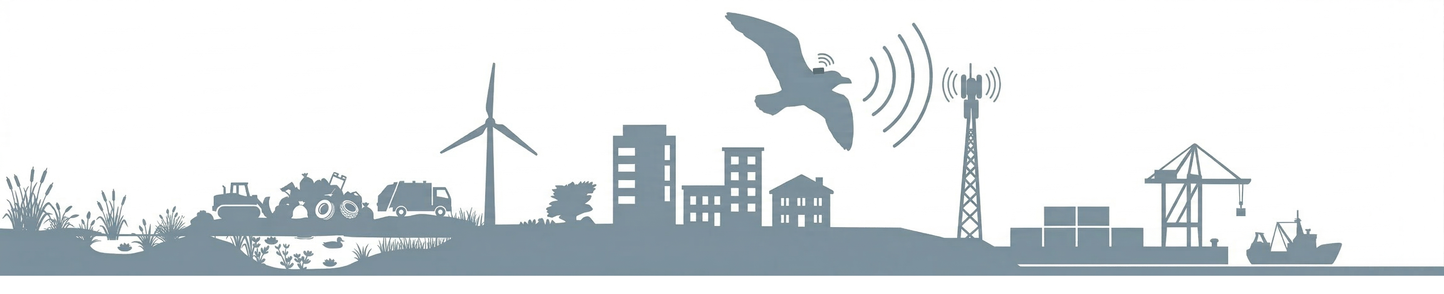
Legend: Telemetric tracking via high-resolution GPS-GSM tags
This diagram illustrates our data acquisition methodology across the habitat gradient. Birds are equipped with miniaturized tags that continuously record their spatial positions and behaviors. These tags use the GSM (Global System for Mobile Communications) network to transmit the collected data via terrestrial mobile phone networks. This allows for real-time information transmission when the bird approaches coastal or continental relay antennas.
1. Habitat selection modeling (Step Selection Functions)
We study a panel of complementary species whose movements cover the entire gradient, from the high seas to inland marshes. Based on GPS tracking data, we apply trajectory analysis models known as "Step Selection Functions" (SSF). This statistical approach compares the bird's actual movements with simulated random movements to mathematically deduce its habitat preferences. Applied to a multi-species context, this method allows for the quantification of attraction or avoidance behaviors in response to cumulative risks and the identification of essential ecological corridors at the territory scale.
Particular attention is paid to the early stages of bird life (juveniles). Due to their inexperience, these individuals explore their environment differently and are often more vulnerable to anthropogenic and environmental pressures. By integrating this aspect into our analytical models, these young birds become early indicators of potential ecosystem dysfunctions. We hypothesize that the study of their behavioral plasticity in the face of multiple risks is a key to anticipating the adaptive potential and survival of populations facing global changes.
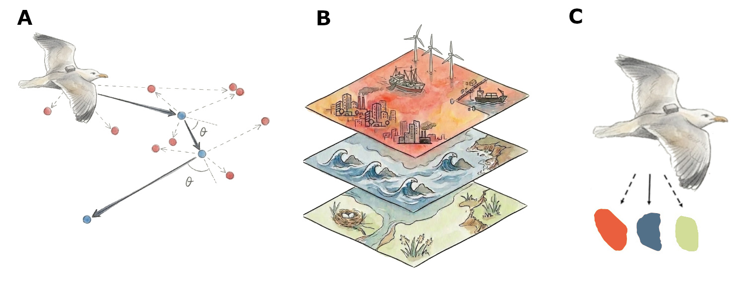
Legend: Analytical modeling via Step Selection Functions
This figure details the analytical approach used to quantify the sentinel birds' response to anthropogenic and environmental pressures.
A. Step selection principle: The actual trajectory (blue dots) is compared to "random" locations (red dots) drawn from observed step and angle distributions.
B. Multi-layer integration: Trajectories are crossed with coastal risk layers and environmental variables.
C. Modeling in R: Statistical analysis estimates selection or avoidance probabilities for different habitats facing cumulative pressures.
Project Leader
Junior Chair Research Professor at La Rochelle University (ExcelLR project). My work within the CEBC focuses on movement ecology and the ontogeny of migratory and dispersive behaviors. Through SENTI-RISK, I develop approaches based on bio-logging and numerical analysis to understand the emergence of individual variability in the face of environmental disturbances. I also participate in the training of undergraduate and graduate students in biology and ecology, particularly on the exploitation of large, complex datasets (modeling with R software).
An institutional and collaborative framework
Hosting: Centre d’Études Biologiques de Chizé (CEBC - UMR 7372 CNRS / La Rochelle University).
Synergy: The project benefits from the interdisciplinary environment of La Rochelle University (interfaces in Movement Ecology, Computer Science, and Coastal Sciences).
Partnerships: The project relies on a multidisciplinary network associating State agencies, public research institutions, private institutes of public utility, and accredited associations for scientific research and nature conservation. These collaborations cover tracking data sharing, technological support for tag deployment, and the implementation of scientific outreach programs in schools (the dedicated partners page is currently under development)
Students: A three-year PhD (2025-2028) and a six-month Master 2 internship (2026) are currently underway.
Science & Society: A transfer component toward school audiences is coordinated with the University's Science and Society unit (dedicated web pages on this site are currently under development).
This work benefits from State aid managed by the National Research Agency under the France 2030 Plan (reference ANR-21-EXES-0010).